

Using people counting technology to improve transport in cities
![]()
One of the benefits of living in a modern city is the access and proximity to resources, work opportunities and entertainment. Efficient transportation plays a key role and in every city, as residents use different modes of transport to get around including walking, cycling, eScooters, cars and buses. Each mode will differ in price, convenience and speed but ultimately all must be efficient and as safe as possible. Residents tend to have a preference and different demographics use modes of transport differently. For example, you’ll find that students will prefer to use public transport, whereas city workers prefer to drive.
It’s important for you to bear this in mind when planning and coordinating transport around cities to ensure that any changes and initiatives actually fit with the way people use services and roadways. Gathering information will be critical and this is where people counting technology can help to enhance awareness, exchange knowledge, and improve sustainability in urban areas.
Determining the transportation profile for the city
Before any changes can be made, it’s key for you to understand exactly how people use different modes of transport. For example, younger people typically use bicycles more, whereas retirees and homemakers may choose cars for comfort and convenience. You can use this information to build a comprehensive transport profile of the city which will inform future objectives and city planning. It also helps you troubleshoot any behaviours which may be negatively impacting city goals.
If reducing congestion and improving air quality are key sustainability objectives, then the information from the transport profile can help you spot contributing factors. For example, residents concerned about safety or with limited access to public transport may use their vehicles more, contributing to congestion, decreased air quality and increased noise pollution. Perhaps there is a lack of available parking in an area with a high volume of traffic or a tendency to use vehicles for short distance journeys because the public transport options are uncomfortable. These insights will help you make tangible changes with an overall positive impact.
People counting technology provides the necessary information to drive change
The first step in building a transport profile is gathering the right data. You can use cameras equipped with people counting software to collect information on the number of individuals and type of vehicles in use in particular areas. Placing these cameras at strategic spots will enable you to better understand different modes of transportation, allowing you to extrapolate and combine data from other sources to compare patterns with demographic profiles. This information allows you to explain and predict the behavior and mobility choices that members of the population would be required to make.
Once analysis of this information is complete, you can implement improvements to modes of transport at the city area level and develop initiatives to encourage the use of alternative types of or more sustainable transportation. For example, in areas that are found to have a high level of pedestrian traffic, you could introduce a Limited Traffic Zone (LTZ) where transit and parking are restricted during the day to prioritize pedestrian and bicycle flow (except for authorized vehicles). If bicycle traffic is increasing, you can assess road layouts to see which can be converted from vehicle streets and parking spaces into bicycle lanes, and improve the cycle lanes, parking areas for bicycles, and bicycle-sharing systems.
Sensors in action – measuring results in real time
This data collection is not a small task, but it can be critical when planning new developments. When planning the neighborhood of Brunnshög in Lund, the environmental impact on the area was at the top of the agenda. To achieve these sustainable objectives, city planners decided that the journeys to and from the area should consist of at least one third walking or cycling, one third using public transport, with the remaining third being car journeys. This was an ambitious intention and the key to success would be measuring how residents were using the different modes of transport over a defined period of time.
The resulting FLOW project is a cross-city collaboration of various organizations to use sensors to gather transport data into a digital platform where it can be analyzed for insights. City planners will then use the information to inform future decisions to support the original objectives and measure the residents’ activity to understand their response to changes. The project is set to run until June 2024 and the ideal outcome will be a safe, accessible and desirable place to live where the attractions of Lund are within easy reach.
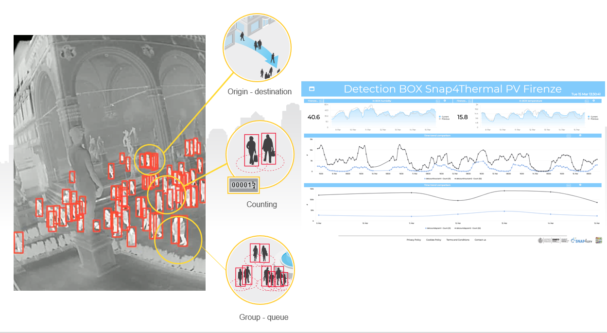
Surveillance cameras can also be used to better understand the flow of people during peak periods to enable better crowd management. Many tourists flock to Europeans cities over the summer months to visit popular landmarks, sample local cuisine and enjoy the nightlife. Florence, Italy typically receives 16 million tourists per year and city officials were keen to gain a picture of how people traversed the popular Piazza Della Signora.
They used thermal cameras placed to strategic points to gather data which was then uploaded to the Snap4City IoT platform, which collects and aggregates data across city services. This helped city officials gather insights on foot traffic and plan future changes to improve efficiencies.
Using data to support the sustainability and longevity of cities
You can use key learnings from your data analysis to shape the activity of the city in a way that supports a high standard of living and wellness for residents. Various initiatives can be introduced as a result, such as promoting cycling to high schools, colleges, universities, and business areas and incentivizing the use of eScooters as another option for those who need to travel quickly.
You can also plan roadworks to improve accessibility and traffic flow, such as the construction of underpasses and flyovers which will help reduce journey times. For those residents who are thinking about switching to electric vehicles to reduce their individual environmental impact, you can introduce more charging points and other necessary infrastructure.
Such an approach would change the city’s dynamic with a positive impact for the whole community, affecting factors such as the commuting experience and time efficiencies, especially during peak hours. This allows communities to reap the benefits of having more time for social and cultural activities, improving their own enjoyment and quality of living.
Find out more about Axis’ smart city solutions